
VISIBILITY STANDARDS
CHANGED
Clifford E Carnicom
Mar 30 2001
Edited Apr 01 2001
The following graphs obtained from the National Climatic Data Center, National Oceanic and Atmospheric Administration, demonstrate a significant alteration in visibility reporting methods as well as data results that warrant a further explanation to the American public.
It will be noted that in October of 1997 a change in the reporting system of visibility data was reduced from a former maximum of 40 miles to a limit of 10 miles. It is a reasonable question to ask as to why that change was made, and whether or not it was made in anticipation of certain events to follow that involve large scale aircraft aerosol operations over large scale geographic regions.
One explanation which has been offered through recent correspondence for the switch to 10 mile visibility limits involves the use of the ASOS, or the Automated Surface Observing System by the National Weather Service, which incorporates a maximum visibility limit of 10 miles. Information on this system can be viewed at the following link:
http://www.nws.noaa.gov/modernize/asostech.html. Any reason for the actual change in standard remains unidentified at this point. Remaining in need of further accounting is the significant degradation in visibility as evidenced by the data which follows this change in standard.
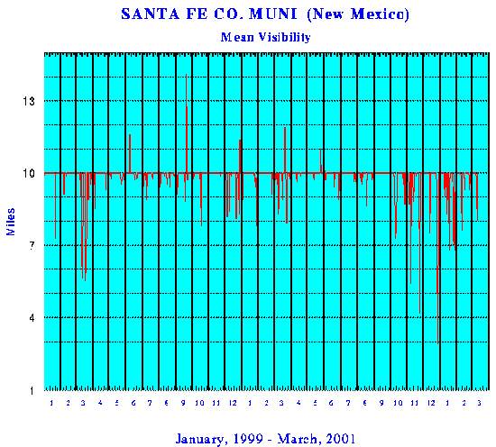
It is observed that there are highly significant degradations in the visibility data immediately following this change in the reporting method. Immediately after this change, the dramatic increase in visibility reports of less than 10 miles is quite apparent.
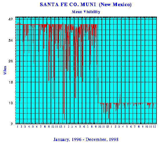
The graphs shown are taken from climatic archive data available for Santa Fe, NM from Jan 1994 to Mar 2001. Three different time periods are shown to aid in demonstrating the magnitude of change which has occurred in visibility. The first graph shows all data available inclusive from Jan 1994 to Mar 2001. The second graph shows the transition zone during which the visibility standards were altered. This graph showns a period from Jan 1996 to Dec 1998; the change in reporting standard was made in Oct 1997. The third graph shows recent data, where visibility below 10 miles is now a regular occurrence. This graph shows the period from Jan 1999 to Mar 2001.
It will be valuable for other citizens to conduct similar archive research in varying geographic regions. This data is available on the NCDC site at http://www.ncdc.noaa.gov/.
It is a reasonable to suggest that an investigation be conducted to seek an adequate explanation for the change of a significant meteorological reporting standard that has been made at a national level, and the subsequent deterioration in visibility that correlates directly with the advent of large scale aerosol operations conducted without informed citizen consent.
VISIBILITY GRAPHS : SANTA FE, NM
JAN 1994 – MAR 2001
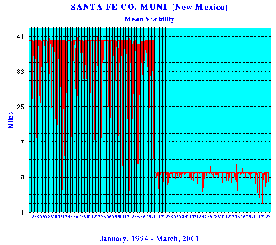
Note: Data points above the maximum reporting standard apparently indicate missing observations.
Clifford E Carnicom
Mar 30 2001
Edited Apr 01 2001
